How to Best See Washington's Mount St. Helens
Along the Spirit Lake Memorial Highway, learn about the effects from the Mount St. Helens eruption.


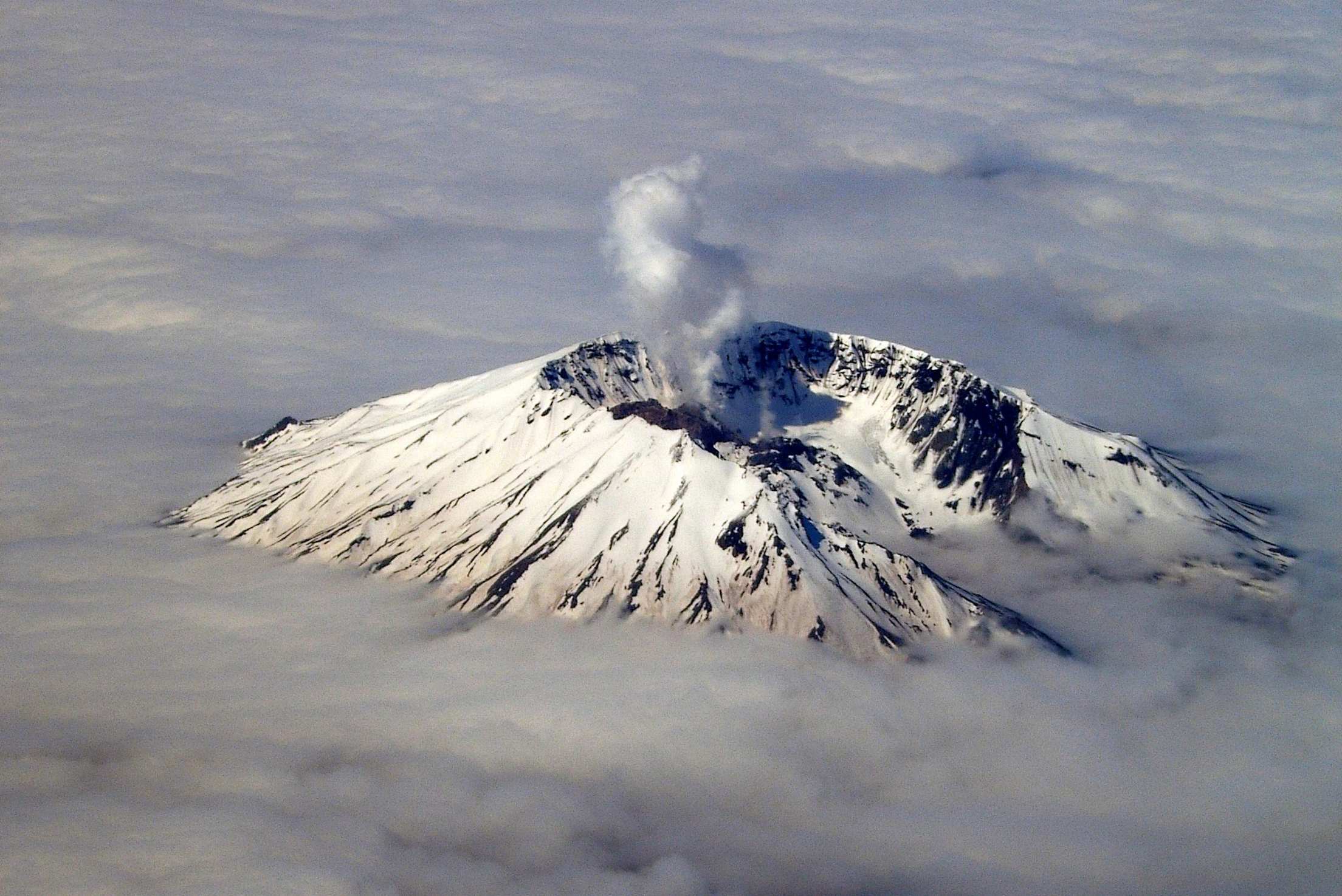
At 8:32 in the morning of Sunday, May 18, 1980, the top of Mount St. Helens "rocketed into the stratosphere."
Hyperbole is quite an achievement when it comes to describing the explosion. Actually, a lot of the mountain blew out laterally, smashing into surrounding hills and valleys. A huge landslide and rushing hot gasses flattened thousands of forest acres. Ash blanketed the scene. The familiar landmarks all were gone. What took their place looked, in the words of Jimmy Carter, "like the moon." Much of the land around Mount St. Helens still does.
On the other hand, the former forest and river valley instantly became "the youngest landscape on earth," and a golden opportunity to see what Nature would do with this vast and nearly lifeless expanse.
You might think an event like that would be considered something of a lemon for the area. But in a large-scale demonstration of lemonade-making, the county, state, U.S. Forest Service, and private industry got together and built a broad scenic route, the Spirit Lake Memorial Highway (SR 504), from I-5 right through the blast area. Along the way are three visitor centers designed to give people the best possible picture of what happened and what’s going on now. "What we have here," boasts one local highway booster, "is 50 miles of accessibility."
Drive the Spirit Lake Memorial Highway (SR 504)
Beginning at the small town of Castle Rock, the Spirit Lake Memorial Highway climbs through forest into the blast zone. It has been opened in sections beginning in 1992, and the final eight miles, up to Johnston Ridge Observatory, opened this May, along with the observatory. For much of the way, there’s a steep drop-off on one side, with views of surrounding mountains, Mount St. Helens, Toutle River Valley, and ridge after ridge of smashed trees. The scenery is progressively more dramatic as the road ascends.
Every few miles, a large visitor center presents itself. There’s little duplication among them; each gives an opportunity for first-class views and each offers a different perspective on the event of May 18.
How big was it?
The mountain shook and bulged for weeks before suddenly losing 1,300 feet of its top in a landslide and explosion that, according to the Forest Service, sent a cloud 15 miles up, blew over 96,000 acres of trees, spread 540 million tons of ash over three states, and killed 57 people. It was the largest landslide in recorded history.
Where’s the lava?
One thing missing from the explosive May 18th eruption was the kind of flowing, glowing lava which helps make Hawaii’s eruptions so picturesque and which contributed to the Hollywood version of the toasting of LA. Later eruptions produced a thick and oozing lava.
An advantage to lethargic lava is that while you might have been smashed by an avalanche, drowned by a displaced lake, buried in ash, or blown away, you could have outrun the lava had it made any real headway. Another advantage is that oozing lava tends to create taller volcanoes with nice cones as it doesn’t spread so rapidly.
Spirit Lake
You can see the drastically altered lake’s south shore from Johnston Ridge. Before 1980 it was a clear mountain lake below snowcapped Mount St. Helens, a popular vacation spot surrounded by forest. When much of the volcano’s north face fell into it, water splashed hundreds of feet up the surrounding hills. Ash and tree trunks filled the lakebed, which is now some 200 feet higher than it was.
Scientists thought it would take many years before the lake would support a wide variety of life again. But, according to the Forest Service, within five years the lake had "virtually recaptured the complexity of pre-eruption life." The land had hardly recovered at all. The lake may be diverse beneath its waves, but didn’t look it the day we visited.
Harry Truman, probably most famous of the eruption’s 57 fatalities, ran a lodge on Spirit Lake. Claiming he was a part of the mountain, Truman refused to leave. He and the lodge still are at the lake’s old level.
And nearby...
About 30 miles south of Castle Rock via I-5, you’ll find the southern approach to Mount St. Helens, SR 503. The stretch we’re interested in begins at Woodland (exit 21) and runs east for 40-odd miles to Swift Creek Dam.
SR 503 is completely different from SR 504. It’s a smaller road going through rain forest and by several small towns. The people there claim, "If you want to see it, go to 504. If you want to do it, come to 503." Outdoor recreation is what you’d do. There are three lakes along the road and access for swimming, boating, and fishing. There are several woodsy campgrounds and lots of hiking. Steelhead and salmon fishing is said to be quite good in the Lewis River.
Ape Cave, accessed through Woodland, is a 12,810-foot tunnel formed from an ancient lava flow (they had faster lava in ancient times). It is open year-round, though the parking lot gets snowed in during winter months. Merrill Lake, north of Yale Reservoir, is a fly-fishing-only lake.
Visitors Centers Along SR 504
Mount St. Helens Visitor Center (Milepost 5)
This Forest Service facility gives an overview of Cascade Range vulcanism and the events before and after May 18, 1980. It’s open daily from 9 a.m. to 6 p.m. in the summer. Winter hours, which begin late in September, are 9 a.m. to 5 p.m. There is an $8 per person fee, good for admission to all three Forest Service centers and other Mount St. Helens National Volcanic Monument sites for three days.
Hoffstadt Bluffs Visitor Center (milepost 27) This Cowlitz County facility gives the first broad panorama of Mount St. Helens, the Toutle Valley, and where the landslide ended. It offers a very nice restaurant, crafts gallery, espresso bar. The architecturally interesting, Alpine-style building features open-beam construction held together by wooden pegs.
Open 9 a.m. to 9 p.m. from May into September. Winter hours vary. Free admission. Helicopter tours are available for $69 per person from 11 a.m. to 8 p.m., mid-May to mid-September, weather permitting. Phone (360) 274-7750.
The Forest Learning Center (6-plus Miles Farther)
A significant portion of the blast area was Weyerhaeuser land. This company-operated center tells of the blast’s effect on the St. Helens Tree Farm and the challenges of salvaging the blown-down timber and replanting. The viewing area gives an excellent overlook of the St. Helens Game Refuge in the valley below and is a good elk spotting area. There is a nice children’s play area. Open daily from 10 a.m. to 6 p.m. May through October. Free admission.
Johnston Ridge Observatory (Milepost 51—The End of the Highway)
From 4,220-foot Johnston Ridge Observatory, most dramatic of the centers, you look straight into the crater at the lava dome, some 5 miles away. You’re standing in the explosion’s direct line—and evidence of what the landslide and blast did is all around you.
The building itself, of glass and tinted concrete, is built into the ridge and looks as though it were already there when the volcano exploded. You can see part of Spirit Lake, Castle Lake, and a broad panorama of mountains in the background. Moonscape is in the foreground and all around you. You park in the midst of it. Johnston Ridge Observatory is open May through November.