Kayaking Below the Hoover Dam
Kayak the Black Canyon National Water Trail below Hoover Dam, ending at Nevada's Lake Mohave.


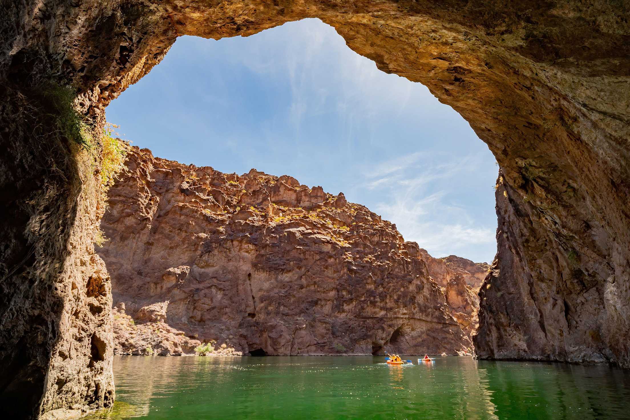
In 2014, the Colorado River below Hoover Dam was designated a National Water Trail, the first so selected in the Southwest. Called the Black Canyon National Water Trail, this 30-mile stretch of flat water teases with strong currents, eddies, and boils.
The water trail begins just below the Hoover Dam, one of the engineering marvels of the world, and passes colorful slot canyons and hidden hot springs that made the river canyon worthy of federal designation. The trail ends at Eldorado Canyon, the historic mining area on Lake Mohave in Nevada.
The Logistics
No matter if you opt to take a guided trip, rent watercraft and guide yourself, or navigate the trail with your own canoes or kayaks, procure permits and transportation to the launch site through one of the authorized outfitters.
Because only authorized vehicles are allowed in the Bureau of Reclamation restricted security area near Hoover Dam, use an authorized service to launch at Hoover Dam if you bring your own private craft. The outfitter you select will transport you to the launch site. A government official must escort you through the restricted security area.
Most adventurers navigate the first 16 miles of the water trail as a day trip and camp overnight at the Willow Beach Marina, which provides abundant time to hike, explore, and soak in the hidden hot springs.
On the Water Trail
At the launch within sight of the enormous dam, put your kayak (loaded with camping provisions for your overnight adventure) into chilly water at river mile 64. Navigation markers indicate the distance in miles from Davis Dam, which is downstream, to Hoover Dam. Then, set off on the water under the world's highest concrete arch bridge, the Mike O'Callaghan–Pat Tillman Memorial Bridge, and below our largest concrete dam. It's a thrilling experience.
At mile 63, on the Nevada side of the river, you can see the stretch of the Colorado River that forms a visible state line separating Nevada and Arizona. Here, enjoy a small lagoon where you can see the bottom of the river through 20 feet of clear water. Once ashore, you'll need a flashlight to see as you work your way through a narrow passageway that leads to Sauna Cave. It's not actually a cave, but rather an exploratory tunnel made during research for the construction of Hoover Dam. When workers encountered 122-degree water, they abandoned this site.
Your next stop, at river mile 62.75, is Goldstrike Canyon. Here, hike up a stream that leads to a hot springs pool. From there, after paddling downstream approximately 1 mile, disembark at Boy Scout Canyon. With the help of a rope, climb up through a gushing waterfall to find more secluded hot pools. Later along your journey, if time allows, stop at Arizona Hot Springs Beach. From there, take an approximately 2-mile round-trip hike to Petroglyph Wash to see images pecked by ancient people into the dark desert varnish that covers large boulders.
As the sun gets lost behind canyon walls, jump out on the Nevada side at a beach between mile markers 59 and 58, and pitch your tent on sandy hills. Watch the last remnants of the sunset while eating dinner around a campfire (your guide service will provide wood, or bring your own). Popping embers and the sound of water lapping on the beach is a relaxing lullaby for day's end.
On day two, there are more slot canyons to be explored. On the Arizona side at mile 53.5, look for ruins of a homestead built for workers who gauged river levels. Here, you also can see the cliffside catwalks and a cable car that carried them to the gauging station on the Nevada side of the river.
On the final stretch to Willow Beach, mile 52, look for Canvasbacks, coots, and other waterfowl. This is a good place to end your kayak trip, with arrangements already made for transportation back to Boulder City, or wherever you are headed next.