What To Do Now in Big Sur, California
Highway 1 is open and the area’s beauty is back within reach.


After three years of revamped itineraries and lengthy detours, travelers can now drive the entire Big Sur coastline, from Carmel to Cambria. Earlier this year, a nearly seven-mile stretch of Highway 1 was cleared of a mammoth landslide that had obstructed the famously scenic route, forcing eager travelers to turn back. Due to a geological makeup of fractured rock, the same sheer cliffs that lend Highway 1 its stirring coastal vistas are susceptible to mudslides and washouts, especially when faced with intense storms like the ones that have blown through the region in recent years. Yet thanks to some inventive engineering and a round-the-clock effort by Caltrans, visitors can enjoy one of the longest stretches of undeveloped coastline in the contiguous United States once again, making stops to snap pics of a beachfront waterfall, pitch camp in a coastal redwood forest, and dine amid the grand-scale beauty of Big Sur.
What to Do in Big Sur Now
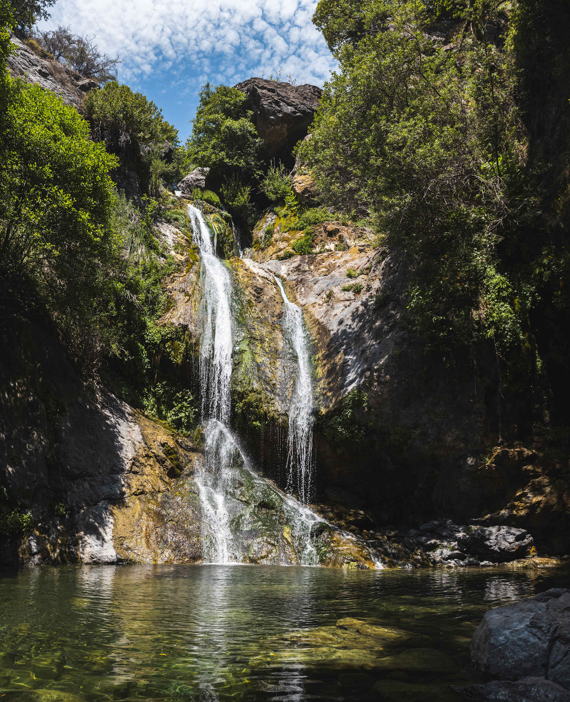
While winter storms may tax Big Sur’s highways, they help fuel the area’s many waterfalls. With Highway 1’s reopening, southbound travelers can now access the lesser-known Salmon Creek Falls, a thundering, 120-foot waterfall tucked in a boulder-filled grotto just a quarter-mile stroll from Highway 1, about 15 minutes from the tiny town of Gorda. At Julia Pfeiffer Burns State Park, rangers expect that, by late summer, visitors will once again be able to access the park’s Waterfall Overlook Trail and catch a glimpse of the park’s iconic McWay Falls as the water plunges onto a secluded beach lapped by crystalline waters. Visitors looking for a day hike that encapsulates Big Sur’s beauty should note the partial reopening of the park’s Ewoldsen Trail, which skirts McWay Creek through coastal redwood groves before climbing through clusters of live oaks to sky-high, coastal panoramas.
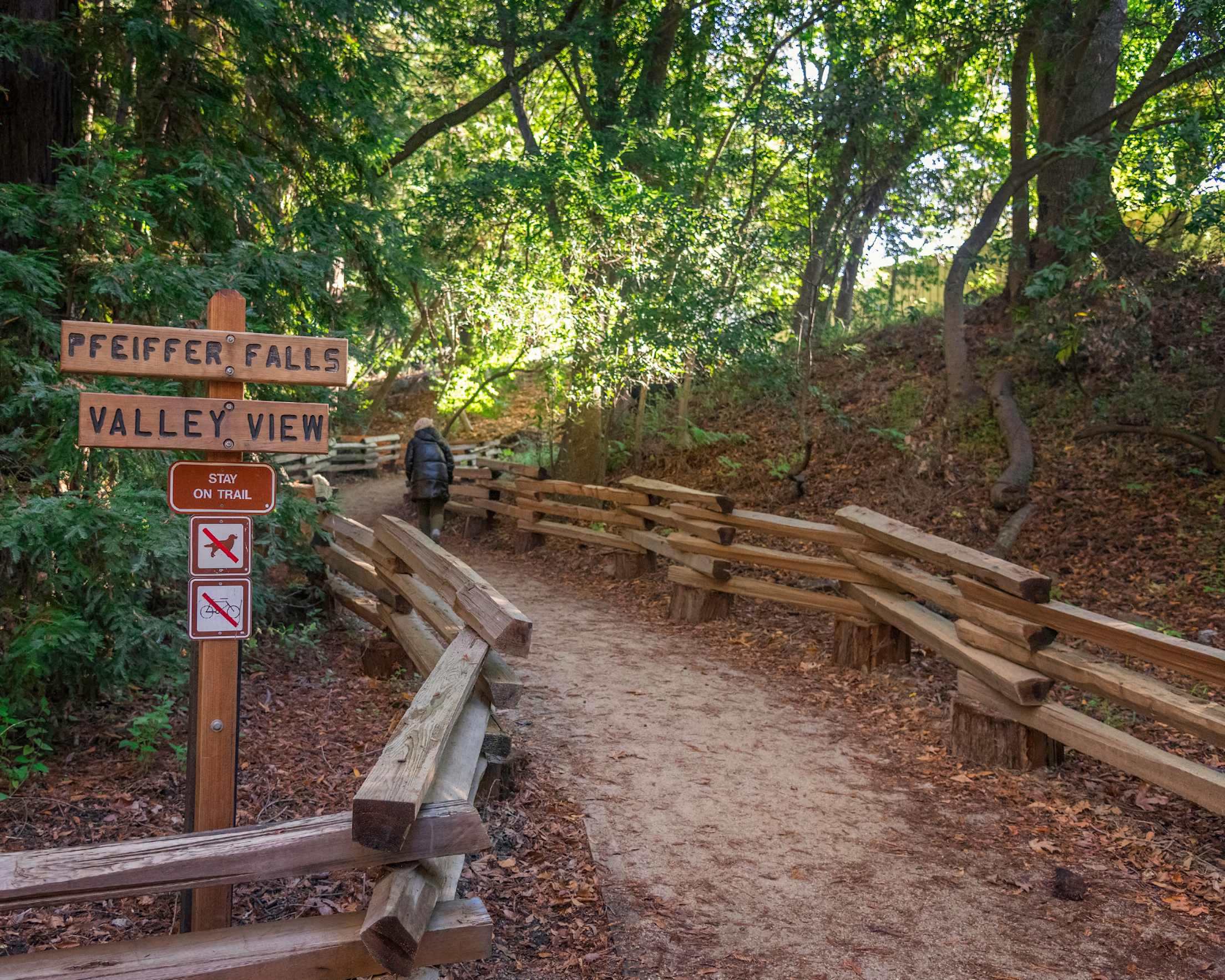
The Pfeiffer Falls Trail at Pfeiffer Big Sur State Park has also reopened, leading hikers on a family-friendly, approximately two-mile trek through a redwood canyon to the base of the 60-foot cascade. From Memorial Day through Labor Day, the park rolls out its summer programming, including nature walks, campfire programs, and Junior Ranger activities. Warm weather also means dips in the park’s gorge, which sparkles with a series of idyllic swimming holes along the Big Sur River. Limekiln State Park’s signature Limekiln Falls Trail remains closed due to continued reconstruction from the 2020 Dolan Fire. However, the park’s campground, slated to reopen by summer 2026, lends the rare opportunity to pitch a tent on the Big Sur shoreline.
Visitors shouldn’t overlook the Discovery Center in Andrew Molera State Park which details one of the greatest wildlife conservation success stories in the world. In 1987, after the California condor was labeled extinct in the wild, the last remaining wild condor was captured into captivity with doubts that the species would ever rebound. Today, you might spot one of over 110 condors living along the Central Coast. At the Ewoldsen Nature Center in Pfeiffer Big Sur State Park, you can measure up to the massive birds—their wingspan stretches over nine feet—at a new, life-size wooden sculpture, and guide your outstretched arms to soar above Big Sur’s hilly coastline via a condor flight simulator.
You’ll enjoy condor-worthy views of the coastline at Point Sur State Historic Park; its historic lighthouse is set atop a behemoth, 361-foot high volcanic rock and has been in continuous operation since its founding in 1889. The lighthouse complex, which retains the feel of its bygone era, is only accessible to the public via three-hour guided walking tours led by passionate docents who delight guests with its thrilling history, including serving as a top-secret Cold War-era naval base. Watch for special events including moonlight and ghost-themed tours (see pointsur.org for details).

Where to Eat in Big Sur
Taking advantage of their coveted setting, many Big Sur restaurants allow visitors to bask in the area’s natural splendor come mealtime. The sprawling garden terrace at The Sur House is set high on a sloping hillside with panoramic vistas of the blue Pacific and Santa Lucia Mountains, while the kitchen features a Cal-Med menu with housemade pastas and organic vegetables from a chef’s garden. Across Highway 1, Post Ranch Inn’s Michelin-recognized Sierra Mar restaurant offers prix-fixe menus that feature local seafood, meats, and produce alongside pinch-me views from its glass-walled dining room and garden courtyard.
Northbound visitors will celebrate a return to the architecturally striking Nepenthe where front-row ocean vistas, the Ambrosiaburger (a ground steak sandwich served on a French roll and topped with their secret sauce), and evening bonfires have made it a quintessential Big Sur destination since 1949. The casual Big Sur Taphouse makes for an ideal post-hike meal with hearty pub-grub fare and a beer garden-style deck with views of the looming Santa Lucia Mountains. At The Village, Big Sur, a rustic-chic complex awash in salvaged old-growth redwood logs and bridge timbers, the upscale Solstice serves seasonally driven dishes prepared on a wood-burning hearth while the all-day Big Sur Bodega has matcha lattes, freshly baked pastries, and picnic tables set under towering sycamore trees near the Big Sur River. Plan your visit to sync with a morning yoga class at the adjacent light-filled studio, Word of Mouth Yoga.
Before You Go
Given the region’s many draws and sizable summer visitorship, it’s worth remembering that Big Sur is fragile and wild. Phone connectivity is often nonexistent on trails and services in town are scant. Before hitting the road, check Highway 1 for potential delays. Park rangers recommend visitors to tread lightly and be mindful of coastal hazards. To help maintain this global treasure, the Monterey County visitors bureau has assembled a list of suggestions to keep in mind on your next visit.