Road Trip to the Arctic
The final link in Canada’s Arctic highway creates the ultimate northern road trip.


Above the Arctic Circle, roads are ephemeral and few, buried beneath drifting winter snows and emerging in summer like a sliver penetrating an endless wilderness of taiga, tundra, and isolated mountain ranges. In 2017, Canada’s Dempster Highway slightly tipped the scales in favor of Arctic road travel as the newest of the world’s three maintained roads landing at the Arctic Ocean.
The all-season, unpaved Dempster originally followed a 19th-century dog sled route 458 miles north from Dawson City, Yukon, to the frontier town of Inuvik in the Northwest Territories. For decades the road ended there, 85 miles short of isolated Tuktoyaktuk (or simply Tuk), a coastal hamlet of 930 residents yearning for a terrestrial lifeline. Six years ago, highway engineers tackled the challenge by building a raised bed of compacted gravel to protect the fragile permafrost. In the months since its completion, the Inuvik-Tuktoyaktuk segment has attracted bold road travelers to its frozen labyrinth of stunted forests, lakes, and rivers spilling toward the Arctic Ocean.
Wilderness, Isolation, and Epic Beauty
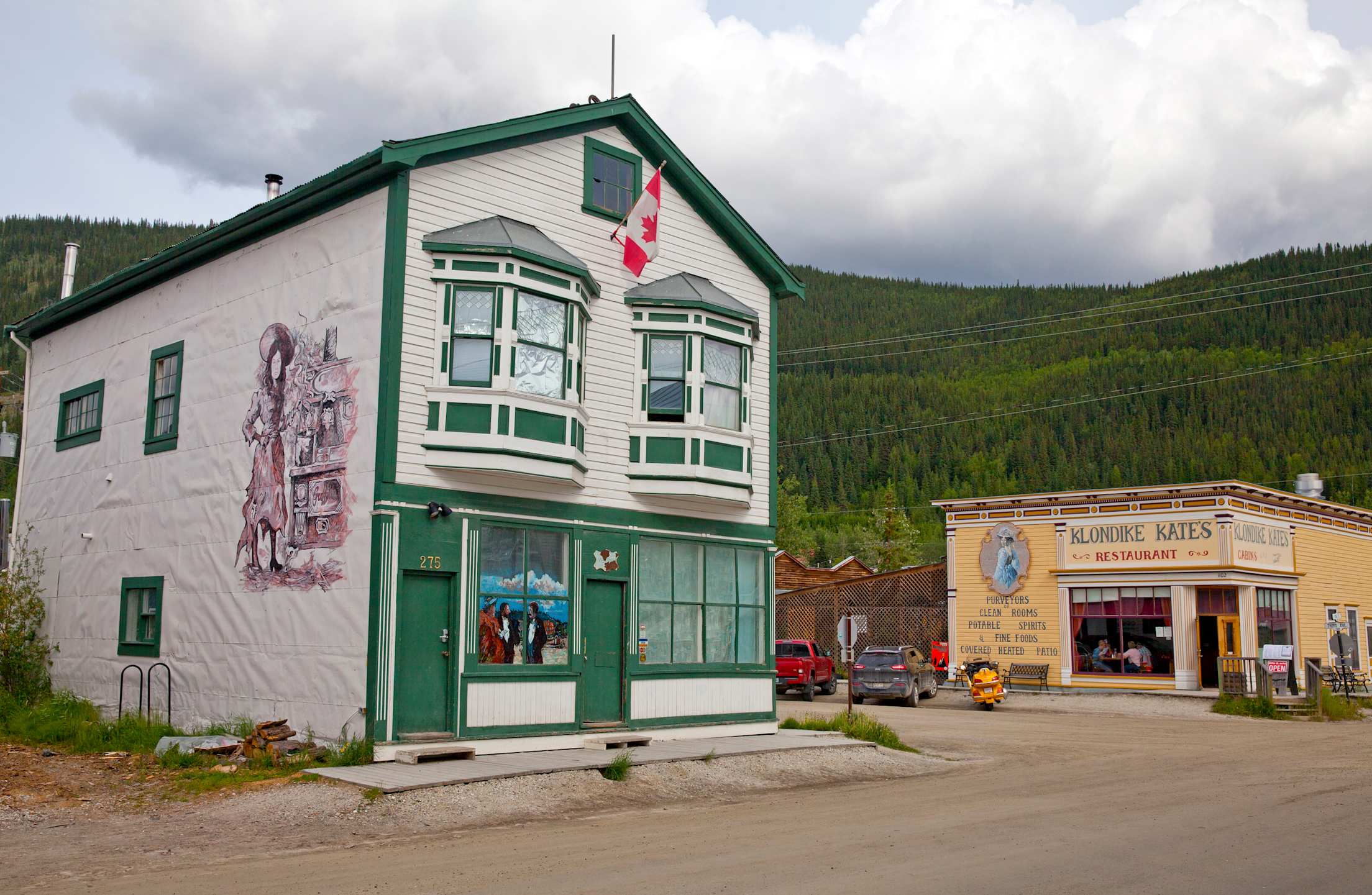
Road trips usually begin in Dawson City, a frontier town, the epicenter of the Klondike Gold Rush where one-time resident Jack London drew his Call of the Wild inspiration, and a seven-hour drive from Alcan Border, Alaska. A few miles east of Dawson, the rugged Dempster Highway peels from the paved Yukon Highway, aiming north through dense spruce en route to the Elysian mountain scenery of Tombstone Territorial Park.
Stop at the Interpretive Center and learn about the ancient Han people and the park’s distinctive craggy namesake peaks. Dazzling viewpoints are literally everywhere and often include sightings of moose, eagles, caribou, black bears, and even grizzlies. Staying close to the car is advised.
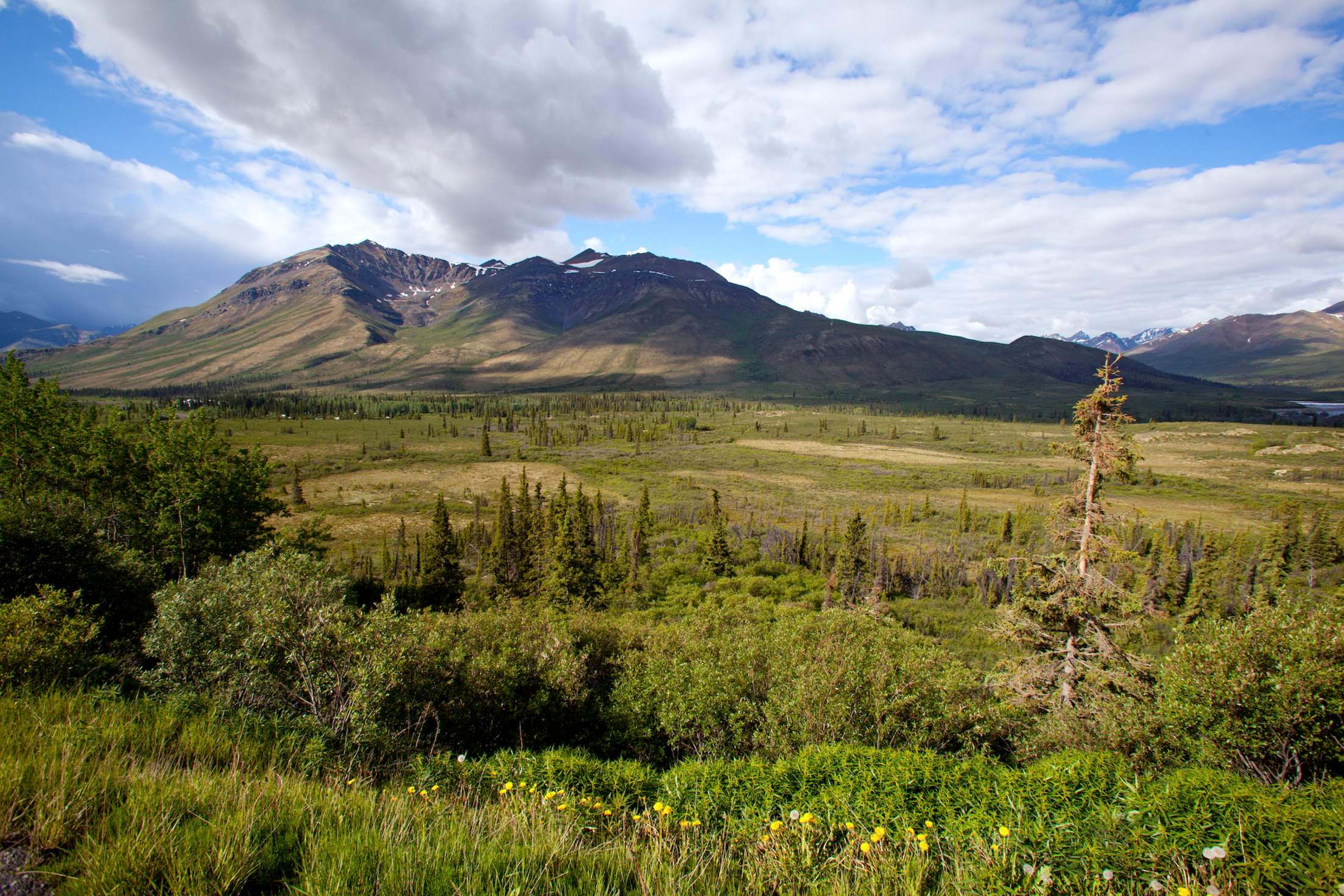
As Tombstone fades in the rearview mirror, the highway is bounded by a “drunken” boreal forest of spruce trees strewn about like pick-up sticks from repeated freezing-thawing cycles that upend their shallow roots. The bizarre spectacle gradually transforms into an ever-broadening landscape of rivers, forest, and isolated mountain ranges home to sparse outposts of First Nation tribes.
Don’t be surprised by the sense of isolation here—with a population density of 0.1 persons per square kilometer, the Yukon’s remoteness can seem overwhelming. A reliable vehicle and proper supplies (extra water, food, and warm clothing) will help steady any unexpected nerves. And during the recommended summer months, you’ll likely encounter European cyclists and motorcyclists, who consider traversing this epic route a badge of honor.
As the road’s rain-carved ruts roll by, waves of scenery can appear like an IMAX movie on continuous loop. But even pageantry needs to hit the pause button, and most drivers rejoice at mile marker 234, where the venerable, rustic Eagle Plains Hotel serves as an outpost of civilization. Gas, food, and lodging make this an essential overnight haven for weary strangers sharing stories of the road while decompressing in the woodsy saloon.
Into the Northwest Territories
Beyond Eagle Plains, the Dempster crosses the Arctic Circle at 66°33' north, a latitude where the sun never completely sets on summer solstice and never rises during winter solstice. A few clicks further and you’ll gaze over the famed Porcupine caribou herd’s winter range, known for the thousands of roving caribou that carpet the valley from September through May.
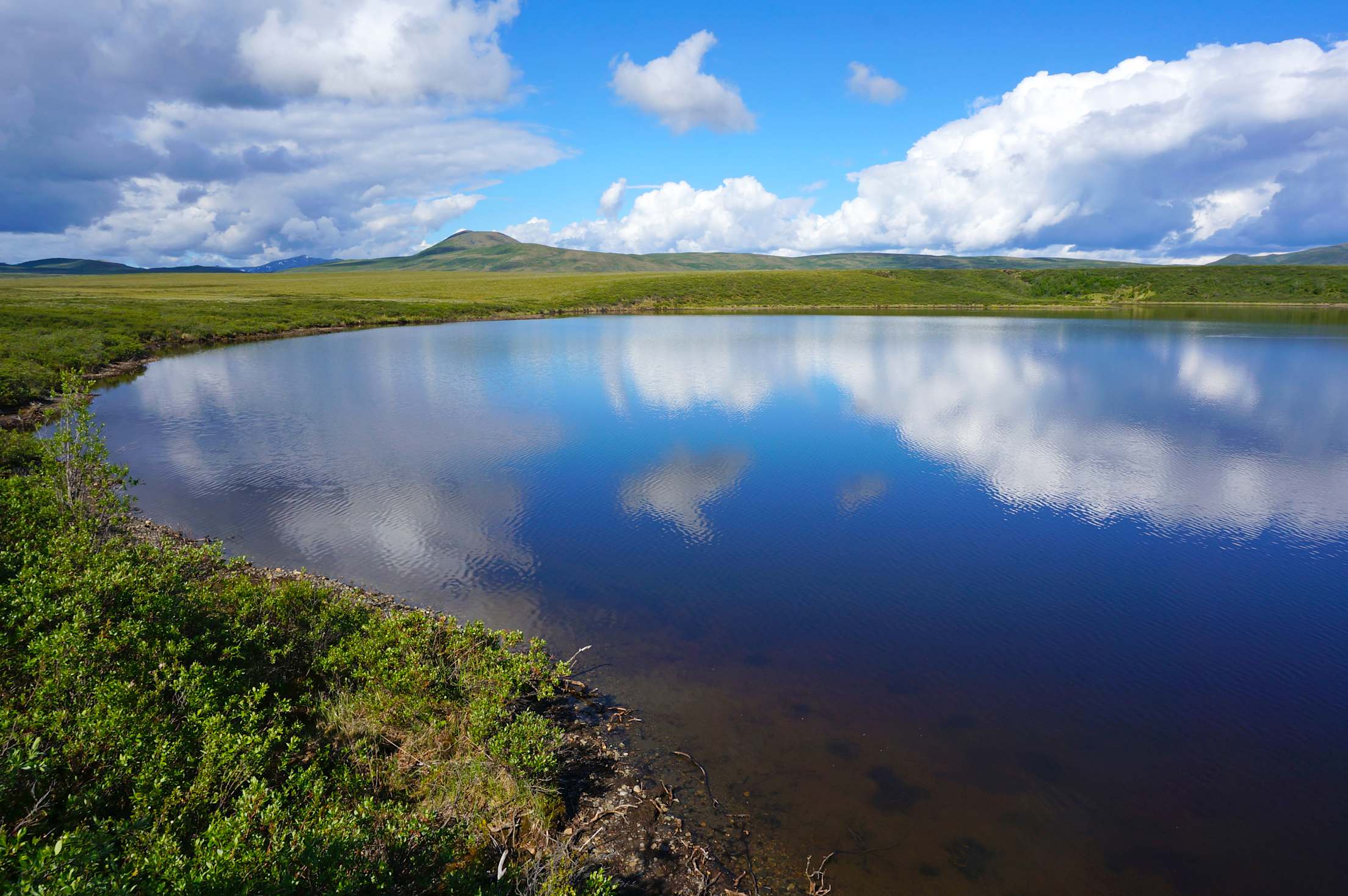
Another 35 miles and the Dempster welcomes travelers to Canada’s Northwest Territories at an interpretive kiosk. During the height of summer, the ground trails here are flanked by crimson alpine tundra and patches of vivid Arctic windflowers of neon intensity, thanks to an insomniatic sun that never sets.
After the Mackenzie River and Arctic Red River Ferry crossing (both free), a two-hour drive past the pristine lakes and forests of Gwich’in Territorial Park lands drivers in Inuvik. On the cusp of the Arctic Ocean, the town of 3,400 residents overlooks the sprawling maze of lakes and waterways of the Mackenzie Delta, and is the territorial homeland of the Inuvialuit and Gwich'in peoples. Travelers can get their bearings and learn about the town’s history at the Western Arctic Regional Visitor Centre, which catalogs and displays important aspects of the land, history, and cultures.
Town locals are especially proud of a singular distinction here: the Inuvik Community Greenhouse—North America’s northernmost greenhouse. Converted from an old hockey arena, the structure is used by residents during the summer months’ 24-hour sunlit days to grow fruits, vegetables, and plants. Tours are available most days throughout the season.
Inuvik marks the beginning of the Inuvik-Tuktoyaktuk Highway, the Dempster’s new, final extension, that starts in boreal forest (or taiga) before abruptly giving way to flat treeless Arctic tundra. The gravel road snakes for 85 miles across the Mackenzie River delta’s countless lakes, ponds, and tributaries, a feat made possible by eight bridges, 359 culverts, and 177 million cubic feet of road material. In the distance you’ll see peculiar Arctic phenomena for which the region is known: the quixotic pingos. Tuk is surrounded by the world’s largest concentration of these large conical hills (formed when bulging ice cores gradually grew as water expanded into ice). About a quarter of the world’s pingos—roughly 1,350—exist on the Tuktoyaktuk peninsula, measuring up to 160 feet high. Many are still growing.
An Arctic End to an Extraordinary Road Trip
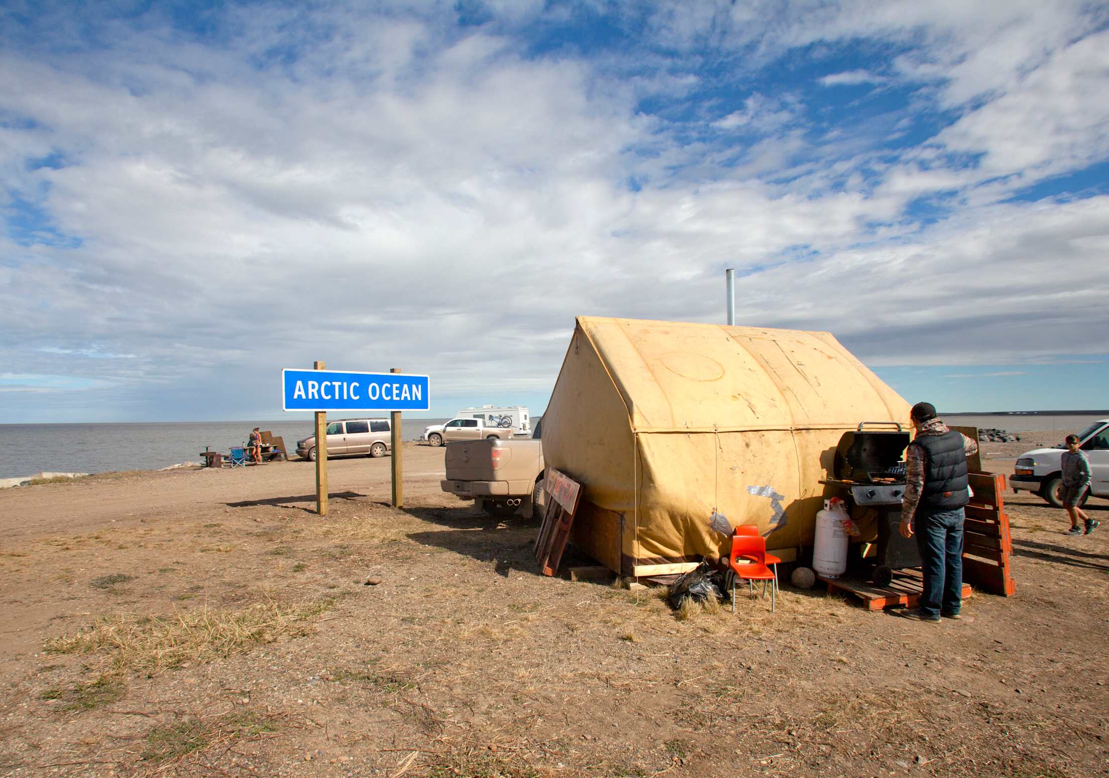
After a two-plus hour drive, the road ends on the pebbly, driftwood-choked shoreline of the Beaufort Sea at Tuk, a hamlet sharing the hard history of the Northwest Territories. Early last century, a significant number of Tuktoyaktuk's native families were wiped out in flu epidemics brought in by American whalers. Christened Port Brabant by early white explorers, the community was renamed in 1950 and was the first in Canada to revert to the traditional indigenous name, meaning “resembles a caribou.” Today, the community is the most culturally intact of any along the Dempster’s route.
Wander around its rows of weather-savaged structures and you’ll find a single year-round eatery, the End of the Road Restaurant, open for dinner every evening. Out on the peninsula there’s a seasonal tented grill serving up musk ox burgers next to a sign proclaiming the road’s end at the Arctic Ocean. Bob’s Gas Bar is usually open daily—a critical link for the return drive to Inuvik. Overnighters can tent camp almost anywhere. A handful of small B&Bs in local homes are another option. WiFi is still a few years out.
On the edge of the continent, Tuk stares out over the Arctic Ocean and marks the conclusion of a road trip where tradition demands a quick dip in the frigid sea—a rite of passage that seems spectacularly surreal considering you’re at the tip of the North American continent.
For now, Canada’s road to the Arctic is an audacious adventure, a throwback to the frontier days of self-reliance and perseverance. And, depending on your DNA, the completed Dempster Highway is an adventurous road tripper’s dream.
If You Go
Canada’s road to the Arctic Ocean crosses some of the planet’s most spectacular scenery. But the drive comes with a few caveats. For most, driving the Dempster Highway is best from about mid-June through mid-September, when the route’s two river crossings are ice-free and made possible by free ferry shuttles. During winter, the entire route is driven on ice, including the frozen river crossings. The spring and fall shoulder seasons—from roughly mid-April through early June and again from October through late November—are impassable because the ferries can’t operate while the rivers are in the process of icing up or thawing. Typical driving speed is roughly 30 mph, conditions permitting.
You can drive hours without passing another soul. Bears, eagles, moose and fox replace humans as local residents and are common sights along the drive. Being grizzly and black bear country, visitors must be vigilant beyond the confines of their vehicle. Services and communities can be well over 100 miles apart. Some road sections may be impassable during warmer months after drenching rains. Road signs are rare, radio stations non-existent, and cell service is unreliable or absent. Emergency provisions (food, water, sleeping bags, warm clothing) are recommended takealongs in case of shredded tires or other misadventures on the road.
For an escorted travel option, Anderson Vacations in Calgary, Canada, operates guided and independent tours year-round (conditions permitting) from Whitehorse, Yuk. to Tuktoyaktuk, N.W.T.
Test your ride's power supply and replace the battery on the spot.