Road-Trip Around Nome, Alaska
Follow three different roads into Alaska’s remote frontier, where musk ox roam, gold glitters, and adventure awaits.


As the days stretch out under the midnight sun, Nome’s wild country calls. Situated on the southern coast of Alaska’s Seward Peninsula, this town of around 3,600 is rugged and remote. Nome isn’t accessible via the state highway system, but it’s a short flight from Anchorage and a popular port of call on Bering Sea cruises. Travelers who make their way here will be rewarded with drives through rough-hewn glacial landscapes, views of musk ox and reindeer herds, and nuggets of gold rush history.
In 1899, miners struck gold on one of Nome’s sandy beaches. By the following year, the town’s population had swelled by more than 20,000, and prospectors’ white tents punctuated the shore for 30 miles. Today, most full-time fortune hunters dredge the seafloor for the shiny mineral; amateur enthusiasts can also pan for gold in designated areas.
Long before the mining boom, this land was home to Inupiaq communities, who crisscrossed the coastline hunting sea mammals, moose, and caribou. Today, over 50% of the town’s residents identify as Alaska Native, primarily Inupiaq, Siberian Yupik, and Central Yup’ik.
Start your coastal journey at the Nome Visitor Center. Leon Boardway, who calls himself the “welcoming committee,” can be found here most days, telling tales and offering advice. The 74-year-old Nomeite recommends renting a car from the Aurora Inn and exploring the three gravel roads that start in town and lead into the wilderness. “Each day, you take a different route,” Boardway says. “They each have their own charm—it depends on what you’re in the mood for.”
Solitude is guaranteed. In some areas, “you’ll see no evidence of humans, and it’ll feel like nobody has stepped here before,” says Boardway.
Day 1: Nome-Teller Road
Traverse tundra meadows and coastal plains on this route, which runs 73 miles northwest of town along the western flank of the Kigluaik Mountains. The first few miles are prime wildlife territory, so be on the lookout for reindeer, musk oxen, and birds from faraway lands. Some 160 species travel to the Seward Peninsula each spring, including Arctic loons, spectacled eiders, and the bar-tailed godwit, which holds the world record for longest nonstop avian flight for its 8,425-mile trek from Nome to Tasmania, Australia.
Pause at the Sinuk River Bridge to gape at the vastness of the valley, rolling tundra, and jagged peaks beyond. Interested in a short hike? Pull over at Mile 48 and head for the rock ledge on the driver’s left. You’ll be treated to sweeping views of hillsides carpeted with reddish-purple Kamchatka rhododendrons.
The road ends in Teller, a small Inupiaq village. From the sand spit at the edge of town, where puffins can be spotted, it’s about 80 miles to Big Diomede Island in Russia.
Day 2: Nome-Council Highway
Start the day in town with an omelet stuffed with fresh red king crab at Pingo Bakery, a cafe that specializes in hearty breakfasts featuring the local catch. Then continue along this 72-mile road that offers coastal beaches, tundra, river valleys, and a boreal forest.
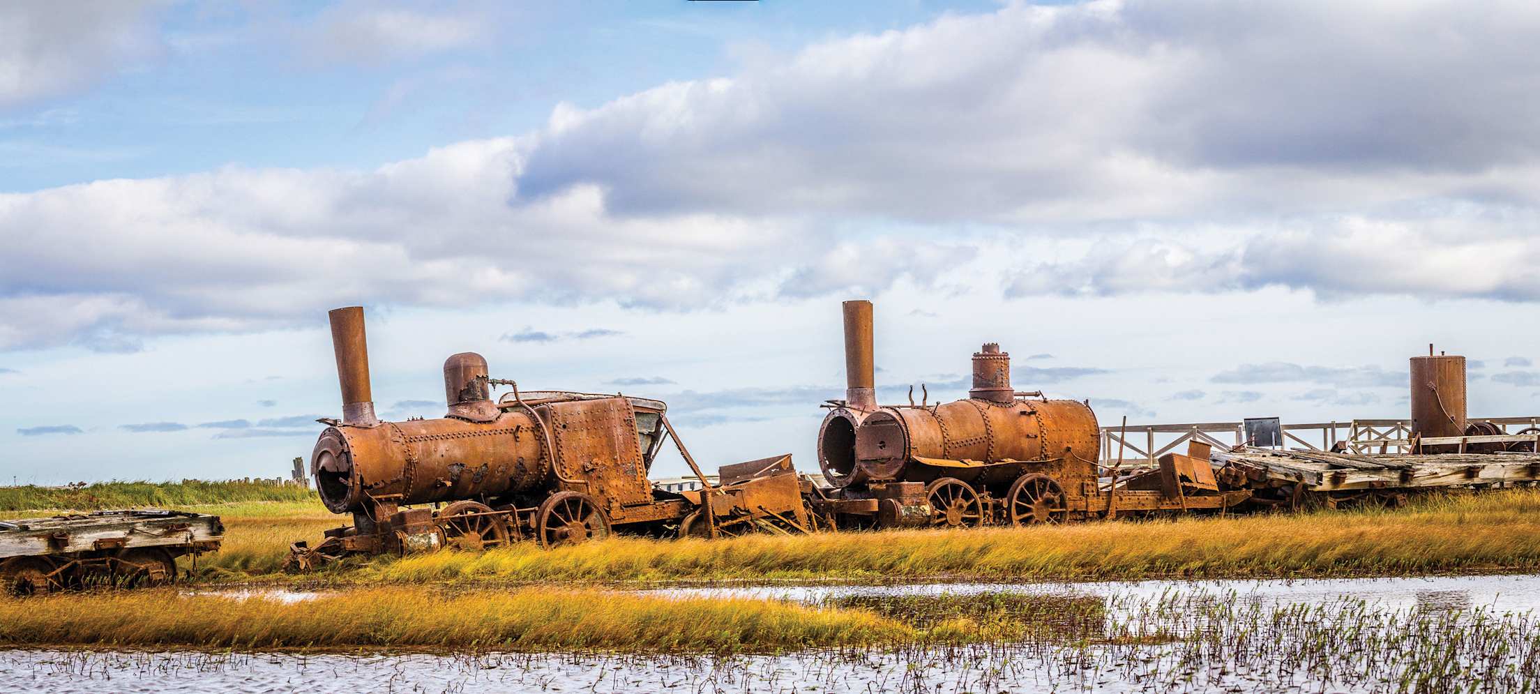
After passing the windswept headlands of Cape Nome, make like a musher and stop at the Safety Roadhouse, the final checkpoint on the Iditarod sled dog race. Snack on free peanuts and tack a dollar to the wall papered with money. Further up the road, at Mile 33, stroll a wooden walkway over a wetlands bog to view the rusted remains of three steam locomotives. Dubbed “The Last Train to Nowhere,” the engines were meant to be workhorses of the region’s mines, but the rail company became mired in debt and a storm permanently stranded them in 1913.
On the drive back, don’t miss the Swanberg Dredge, which dates to the 1940s. On the town’s western edge, fans of the Discovery Channel’s hit series Bering Sea Gold will also recognize the Port of Nome, home to an eclectic assortment of modern dredges.
Day 3: Nome-Taylor Highway
More commonly called the Kougarok Road, this route is Boardway’s favorite. The roughly 86-mile journey begins at the edge of the Bering Sea and travels northeast into the craggy Kigluaik Mountains. “You get into those mountains, and they just keep going,” he says. “It’s quite a feeling when the serenity takes over.” The road crosses several clear-flowing streams, including the Nome and Grand Central rivers, where folks fish for Arctic grayling, Dolly Varden, and four species of salmon.
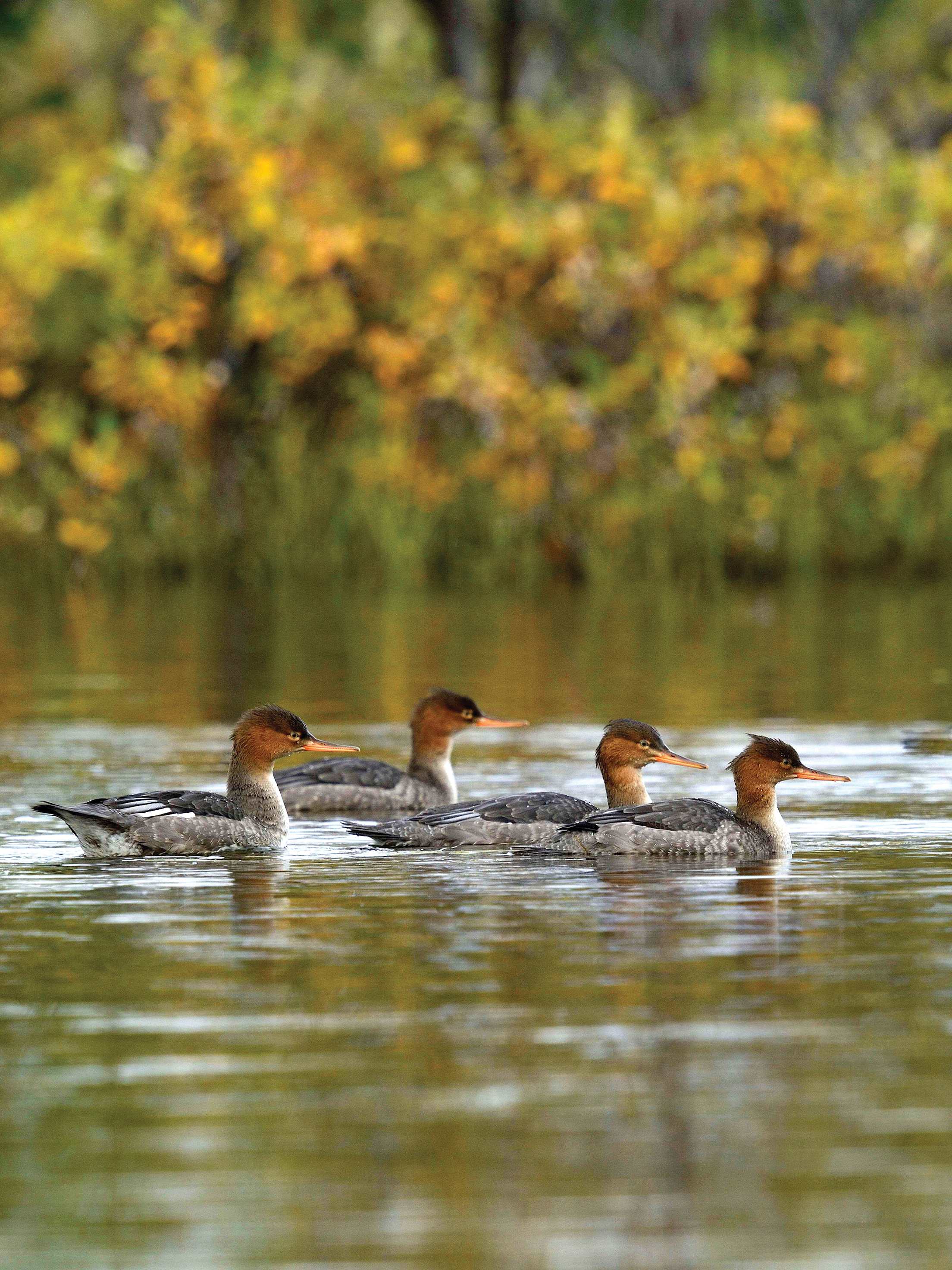
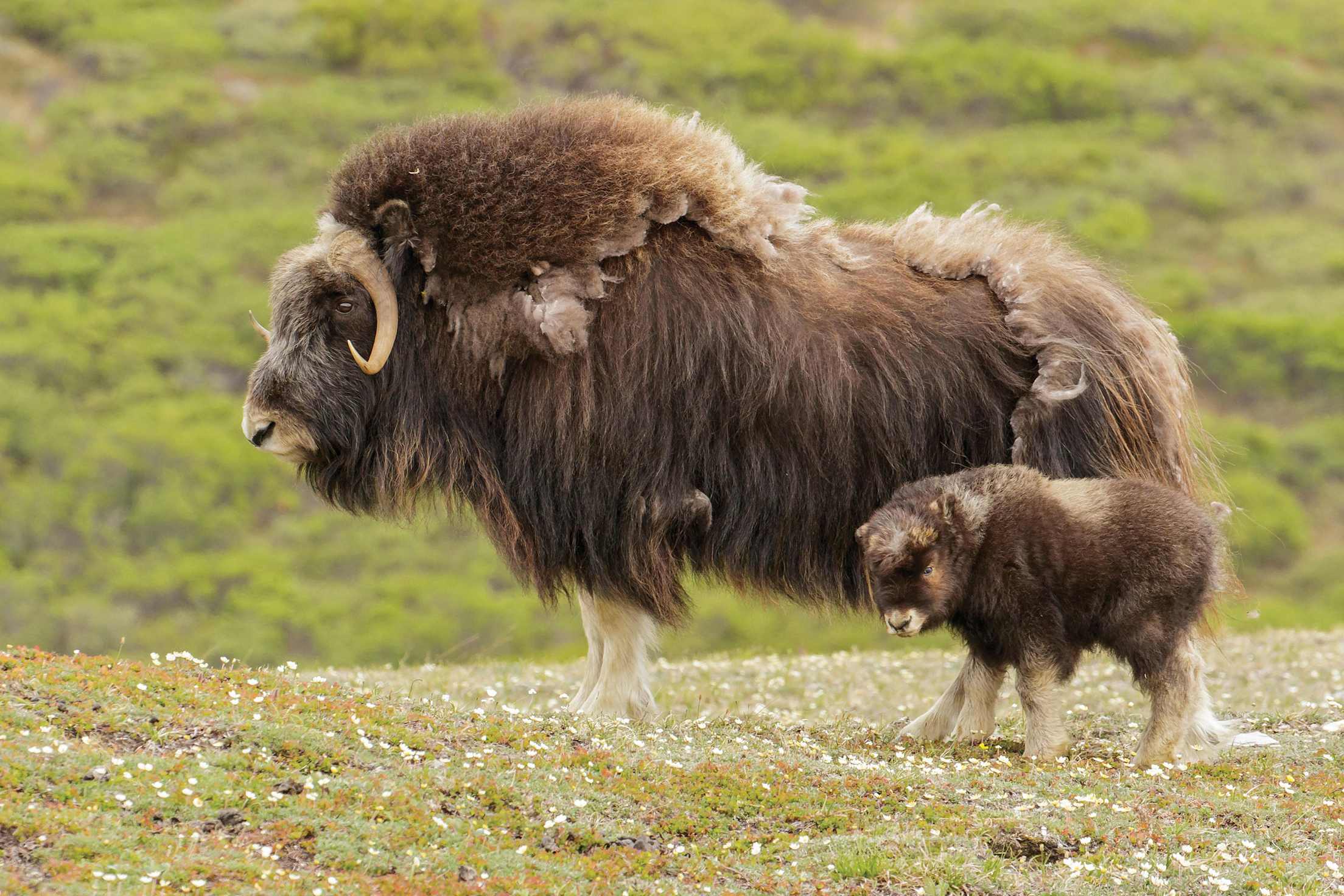
Keep your eyes peeled for musk ox along the way; there are an estimated 2,000-plus on the peninsula, and their favorite hangouts include ridgelines and hilltops. Near Mile 25, look closely at the rocky outcrops on your right, and you might spy raptor eyries. At Mile 35, spend some time birding at the Grand Central River Bridge. Listen for warblers in the willows and watch harlequin ducks and red-breasted mergansers in the rushing river below. In late summer, grizzlies peruse the banks for spawned-out salmon and juicy berries.
Boardway encourages photographers to use their peripheral vision when scanning the landscape for wildlife. “If you notice something that doesn’t belong, that will be an animal,” he says. “And don’t even think about edging up close to them.” Keep your distance, snap a photo, and treasure your encounter with this remarkably untamed place.
Explore the Alaskan wilderness on a one-week guided tour available through AAA Travel.