21 Best Hikes Across the West
Check out these hikes in state parks and other public lands instead of crowded national parks.


From azure alpine lakes to vibrant red rocks, delicate wildflowers to staggering redwoods—these hikes have it all without the hard-to-get permits, timed entry, or jockeying at the trailhead that are common at many national parks across the West.
Alaska
This is a land of superlatives. The country’s largest state, Alaska is also its wildest, with more rivers and forests than anywhere else. It’s the least densely populated state, but also the richest when it comes to state parks: More than 3.2 million acres of land are protected within 120 state parks, the largest swath in the country. This is big, big country with dramatic weather and fierce creatures, so hire a guide if your wilderness skills could use more work.
Where to Go
Chugach State Park is the third largest in the state at more than 495,000 acres, which makes it actually bigger than California’s Kings Canyon National Park. And it’s right on the eastern edge of Anchorage, making Chugach one of the most accessible parks in Alaska.
What to Hike
Day hikes abound, of course, but you should go big and book a backpacking trip to get the full Alaskan experience. Go Hike Alaska offers three-day guided trips to Williwaw and Long Lakes, a 20-mile adventure that will take you past dazzling waterfalls, into gaping valleys, and on to lakeside campsites. Along the way you’ll look for moose, mountain goats, and, of course, bears.
Also Great
Denali State Park shares a boundary with Denali National Park but has fewer crowds. Go Hike Alaska offers five-day backpacking trips along the K’esugi Ridge, a 30-mile traverse with fantastic views of North America’s tallest peak, 20,310-foot Denali.
Accessible Option
In this case, give in: Take the Glacier View Loop in Kenai Fjords National Park, which runs for a mile to a viewpoint overlooking the impossibly jumbled Exit Glacier as it tumbles out of the Harding Icefield.
Arizona
With three national parks, 34 state parks, and more than 7,000 miles of hiking trails, Arizona is hiker heaven, and we’re not even talking about the routes that go deep into the Grand Canyon. This state is much, much more than desert, with hidden oases and incredible geology. Lace up the hiking boots and be prepared to be awestruck.
Where to Go
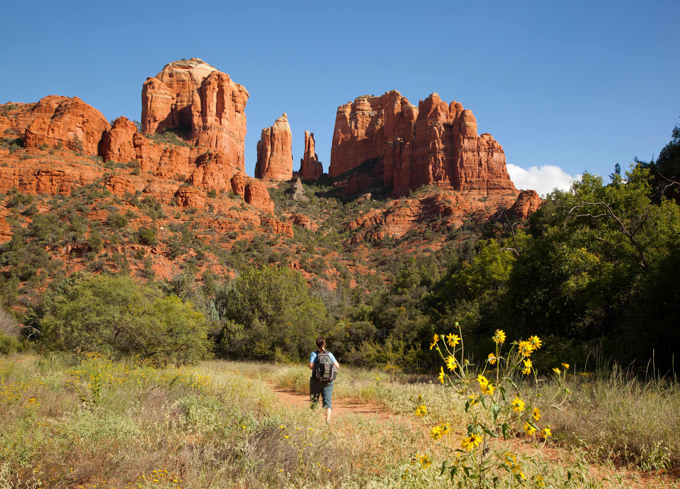
Sedona’s spectacular red rock domes and spires are world class by any measure and well worth a trip even if it means skipping the Grand Canyon. Hundreds of trails wend through this country, which is so inspiring that walking amidst it will leave you energized. Or is that the vortex that some believe this place to be?
What to Hike
No matter where you go, your choices for hikes here fall into three categories: winning, winninger, and winningest. It’s hard to go wrong with the Cathedral Rock Trail, a steep 1.2-mile out-and-back trail that climbs up into the red rock spires, with jaw-dropping views of more pinnacles and ledges everywhere you look. Time your visit for sunset for the winningest of them all. Pro tip: Skip the hassle of trying to find a parking spot at the trailhead and instead catch a free shuttle from town.
Also Great
For a somewhat longer option in similarly spectacular country, try the Devil’s Bridge Trail off Dry Creek Road. The 3.9-mile out-and-back route takes you to the namesake, a 50-foot-high sandstone arch set among heavenly views of striated mesas and buttes. The free shuttle from town takes you to the trailhead.
Accessible Option
Tonto Natural Bridge State Park near Payson features what’s quite possibly the largest natural travertine bridge on Earth, a 183-foot-high marvel with a 393-foot opening running through it. A paved trail leads to a viewpoint overlooking it.
California
Hikers and outdoor enthusiasts need no introduction to California, home to national park gems such as Yosemite, but did you know it also has 270 state parks, the most in the country? One of them, Mount Diablo State Park, includes a vista point from which you can see the largest area of the Earth’s surface viewable anywhere outside of Africa.
Where to Go
Castle Crags State Park, about 14 miles south of the town of Mount Shasta, features views of 6,000-foot-tall granite spires that are more than 170 million years old and scream into the sky so awesomely that they seem straight out of a fantasy novel. Nearly 30 miles of hiking trails, including portions of the Pacific Crest Trail, punch through the park.
What to Hike
The 5.2-mile Crags Trail is arguably the park’s most popular and challenging route, as it takes adventurers up more than 2,000 vertical feet, close to the top of the incisor-like Castle Dome. There you’ll get a panorama of spires and icy volcanoes you’ll never forget. This is the only trail that will take you up into the granite teeth, but be forewarned: The route can get steep at times, and your neck may ache from all the looking around you’re bound to do.
Also Great
Garrapata State Park near Carmel has it all: wildflowers, redwoods, and great views of the craggy Northern California coast. The 2.8-mile out-and-back Soberanes Canyon Trail goes through it all.
Accessible Option
Stout Grove in Jedediah Smith Redwoods State Park features one of the most picturesque stands of redwoods on the planet, with trees that reach more than 300 feet off the forest floor. A half-mile paved loop trail takes you into the heart of it.
Montana
As the fourth-largest state but ranking just 43rd in population, Montana is something like the Alaska of the Lower 48: wild, gorgeous, and brimming with adventure. Glacier and Yellowstone National Parks are delightful indeed, but Montana also has 55 state parks that inspire.
Where to Go
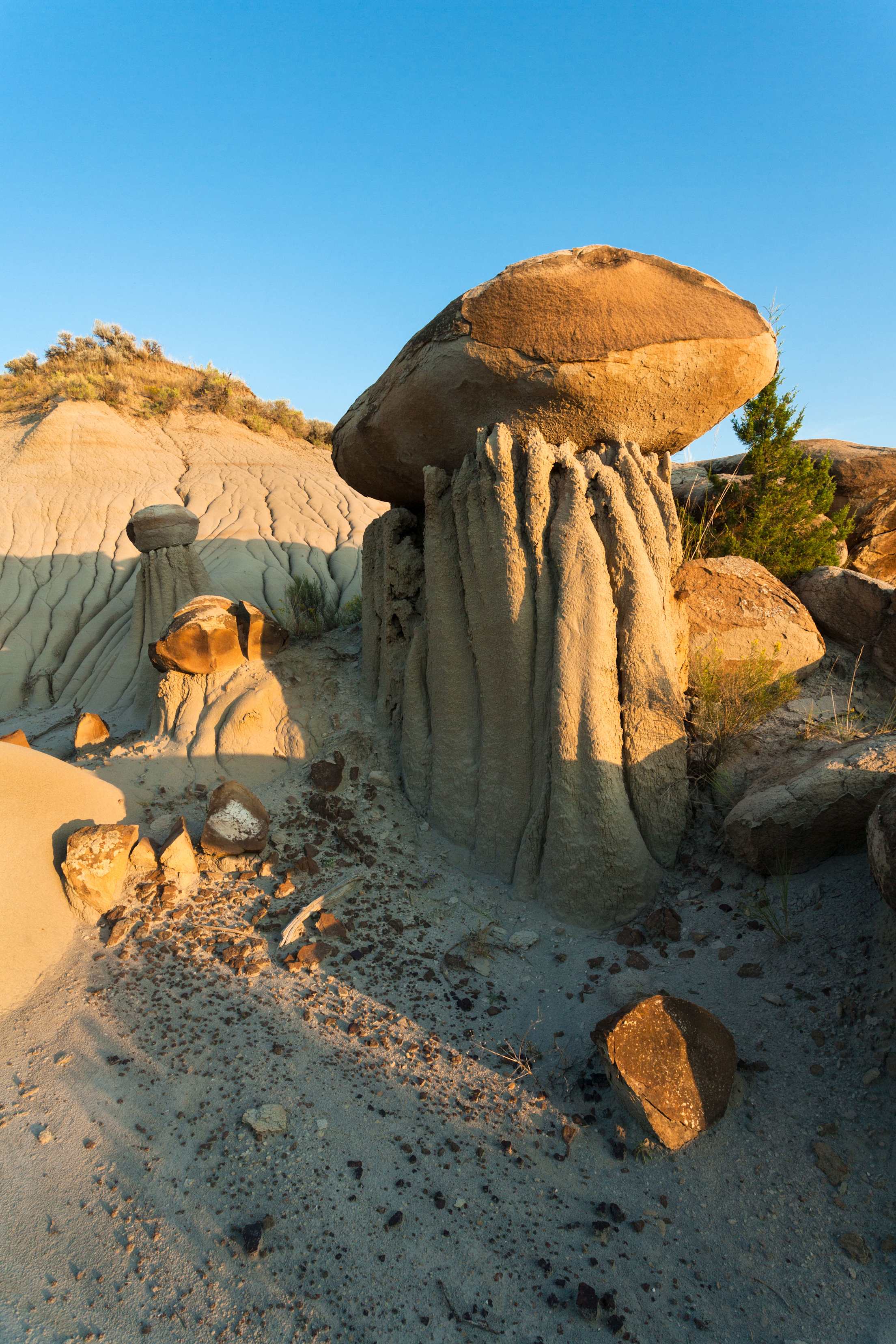
Located in far eastern Montana near Glendive, Makoshika State Park—Montana’s largest at more than 11,000 acres—is well worth the effort it takes to get there, thanks to the otherworldly, truly bizarre “badland” formations of towering, crumbling earth and sandy canyons. This area is one of the richest places on Earth for dinosaur fossils since prehistoric creatures such as the frightful Tyrannosaurus rex roamed the region when it was a tropical flood plain.
What to Hike
Many of the trails here are less than a mile long, with hoodoos, natural bridges, and deep ravines (“coulees” in these parts) making some of them great for little kids. For a longer stroll, head out on the Gunners Ridge Trail to the Hungry Joe Overlook, a 4.4-mile out-and-back hike that takes you up along an airy ridge with panoramic views deep into the surreal landscapes. Don’t go right after a rain (when the area is very muddy), and do bring a map and water. The route isn’t always very well marked and has zero shade. Check in at the visitor center to find a guided hike with a park paleontologist, offered on Saturdays in June and July.
Also Great
For an easy taste of Montana’s alpine grandeur, take a drive along the Beartooth Highway between Red Lodge and Cooke City, climbing to more than 10,000 feet. Or for a real challenge, take a 13-mile day hike off the highway to Black Canyon Lake, a stunning turquoise gem set below the sheer face of 11,401-foot Thunder Mountain.
Accessible Option
Pictograph Cave State Park near Billings has a half-mile loop, much of it paved, to view rock art created as long as 2,000 years ago.
Nevada
World famous for places such as Las Vegas and Reno, Nevada is also home to a vast natural terrain full of Ice Age fossils, cultural and historical sites, and nearly 30 state parks in landscapes that make for unforgettable hiking.
Where to Go
Some 150 million years ago, shifting sand dunes slowly formed into a swatch of magnificently striated sandstone that is now the backbone of the Valley of Fire State Park. Wander among these candy cane–colored hills and you’ll find 2,500-year-old petroglyphs, petrified trees, and other marvels.
What to Hike
More than 20 trails wend through the park, but you should link a few of them together. The Fire Wave, White Domes, and Seven Wonders Loop is actually two relatively flat loops that run for about 3.2 miles through some of the most colorful and peculiar sandstone formations. Red, orange, and white swirls lead to slot canyons and sweeping views of odd formations such as Elephant Rock, which really does look like its namesake.
Also Great
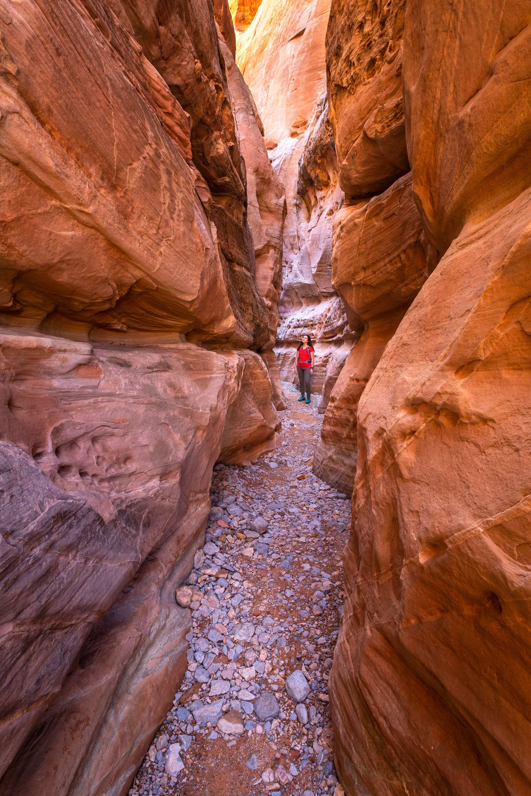
Looking for a place near Vegas? Head out to Red Rock Canyon National Conservation Area for a 2.1-mile hike into the cool world of Ice Box Canyon, a tight gorge where you’re certain to see rock climbers scampering up the towering sandstone walls. You may need a timed-entry permit, depending on when you visit.
Accessible Option
The River Mountain Trails Loop east of Las Vegas runs for more than 30 miles, much of it along Lake Mead. All of it is paved.
Utah
Anyone who’s ever been to Utah knows firsthand what a wonderful freak of nature the state actually is, with majestic peaks, squeeze box canyons, and a landscape full of flaming red-rock hoodoos seemingly on loan from a Warner Bros. cartoon. While the “Mighty Five” national parks get lots of well-deserved attention—Bryce Canyon, Canyonlands, Zion, Capitol Reef, and Arches—the state also has 46 state parks and countless quieter areas to explore.
Where to Go
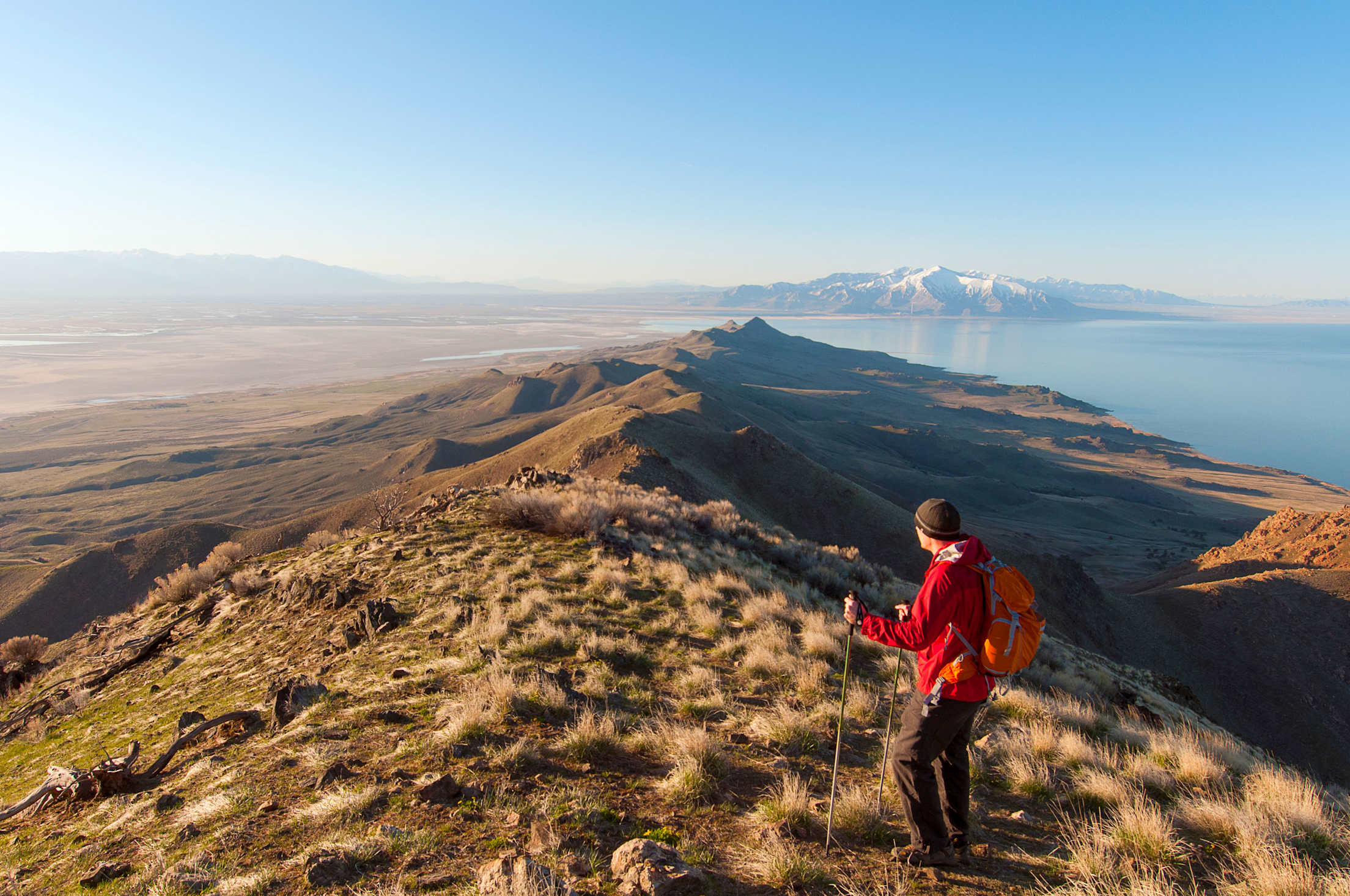
Tucked in the southeastern portion of the Great Salt Lake about 45 miles northwest of Salt Lake City, 42-square-mile Antelope Island is the largest of the lake’s 10 islands, mostly protected as a state park. Here you’ll find the local celebrities: as many as 700 wild, free-roaming buffalo, the largest herd in the state. Forty-five miles of trails weave across the island, too. Don’t miss a visit to the Fielding Garr Ranch, one of the oldest ranches in Utah, where buffalo often graze nearby.
What to Hike
Many of the trails on the island are open to mountain bikers, but not the Frary Peak Trail. Head out on this seven-mile out-and-back hikers-only route that climbs 2,329 vertical feet up a well-defined trail to afford sweeping views of the Great Salt Lake. Bison blocking the trail? Give the beast a very wide berth, and never approach one. They’re shockingly swift.
Also Great
Escape the state’s sweltering heat with a hike in Cedar Breaks National Monument, a Bryce Canyon look-alike set more than 9,000 feet up in the mountains over Cedar City. The Spectra Point and Rampart Overlook Trails will take you about seven miles out and back among ancient bristlecone pine trees and views into a polychrome canyon. Put your camera on panorama mode and leave it there.
Accessible Option
Antelope Island State Park has a “trail chair” at the visitor center that’s rugged, comfortable, and ready to tackle most trails, as long as you have two other people ready to assist.
Wyoming
With fewer than 600,000 people living within its borders, Wyoming counts as our least populated state, with the lowest population density of all but Alaska. Translation: It’s a wonderful place to wander. Grand Teton National Park, Yellowstone National Park, and Devils Tower National Monument may be the main stage acts, but the Cowboy State also has 12 state parks and millions of acres of protected public lands.
Where to Go
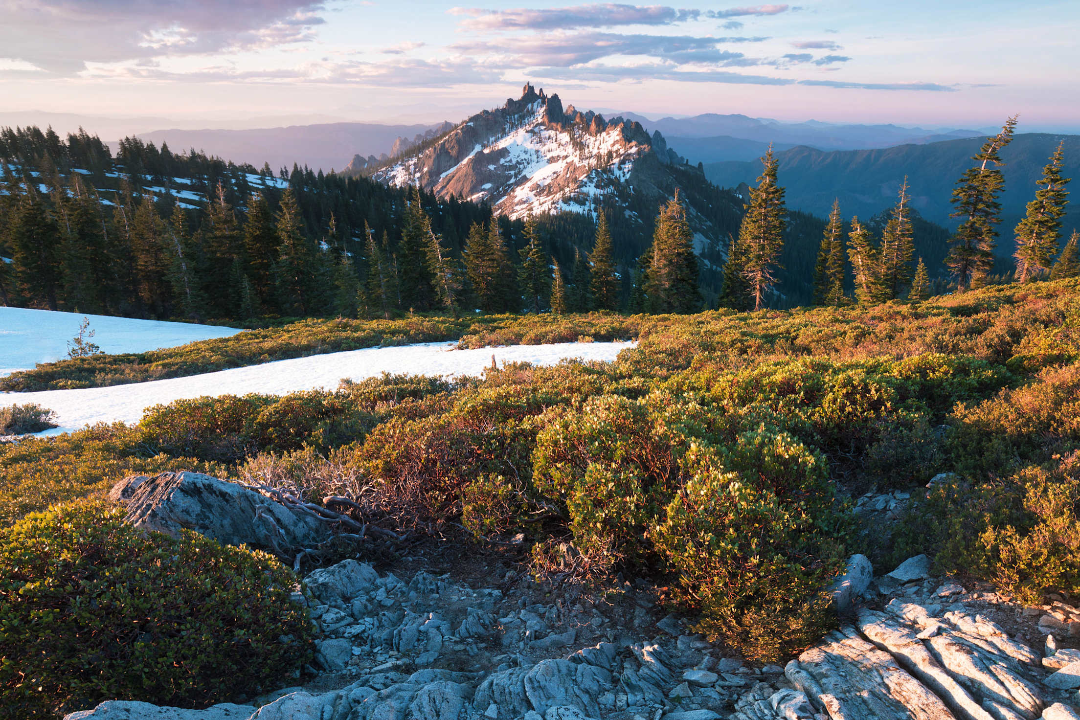
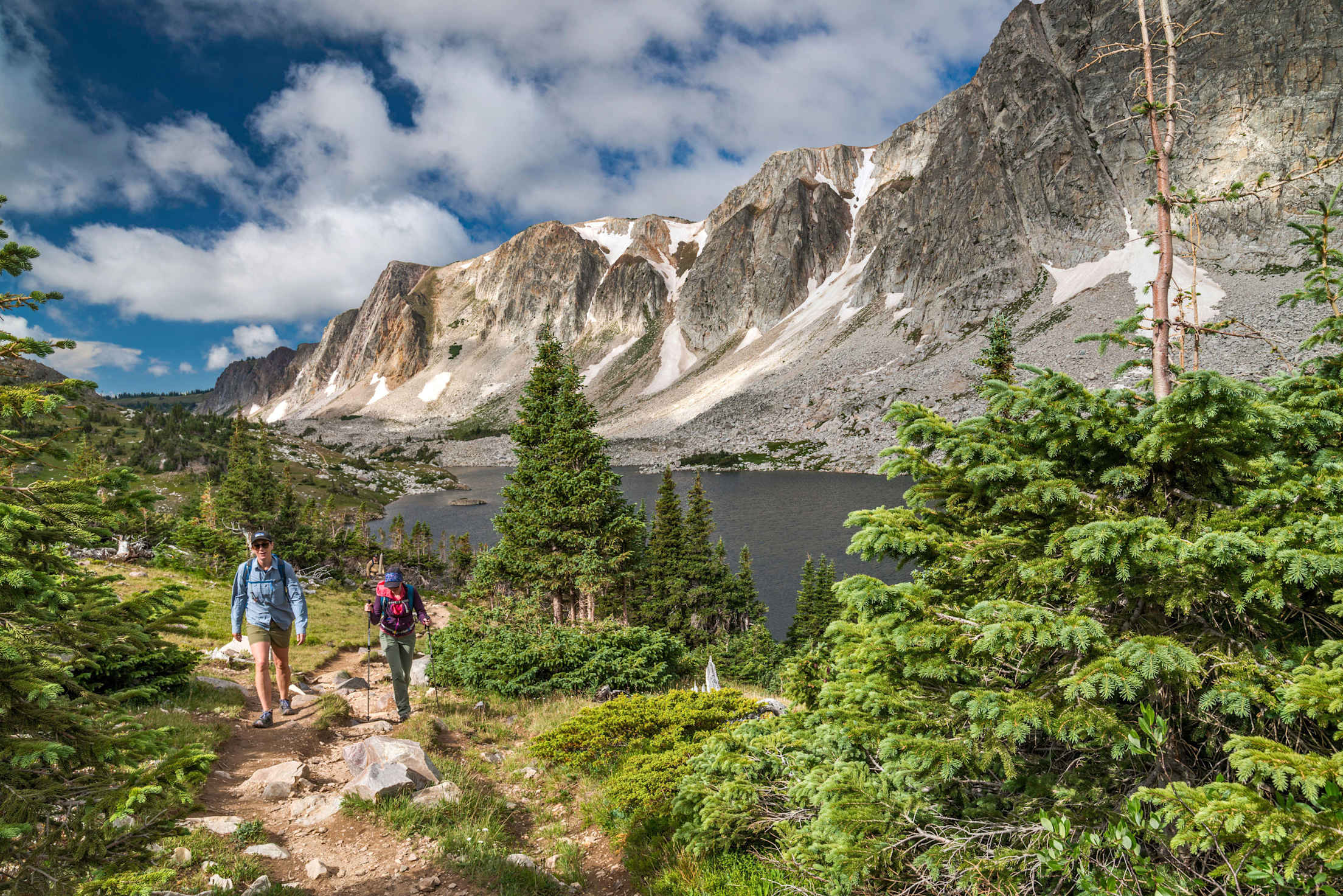
The Medicine Bow–Routt National Forest covers nearly 3 million acres of southern Wyoming and northern Colorado—a spectacular swatch of ragged mountains, grasslands, and lakes, with airy views that you won’t have to share with the masses. Within that forest, the Snowy Range west of Laramie includes more than 40 trailheads and day-hiking areas that highlight the most photogenic parts. Go there.
What to Hike
At about 12,000 feet high, Medicine Bow Peak in the southern part of the state rises over twinkling alpine lakes like a giant backstop made of quartzite. The seven-mile Medicine Bow Peak and Lakes Loop takes you to the top of the peak, the highest in the range, on a well-marked trail that entails about 1,700 feet of elevation gain. One option: Start off at the Lake Marie Picnic Area about 14 miles west of Centennial on the Snowy Range Scenic Byway, and hike the loop clockwise for the most breathtaking views. Be sure to get an early start. Afternoon storms routinely roll in with little warning.
Also Great
Glendo State Park north of Cheyenne has more than 45 miles of trails across its 22,000 acres. Try the Twenty 15 and Narrows Bluff Loop, a mostly flat 3.5-mile circuit with views over the waters of the North Platte River and the Glendo Reservoir.
Accessible Option
Hot Springs State Park along the Bighorn River near Thermopolis does indeed have hot springs, including a free bathhouse with 104-degree water. After a soak, check out the accessible trails that offer close-up views of thermal terraces and pools.
AAA Members save up to 10% on hotel rates.